Pontoon & vessel-based borehole drilling
ASTM D2113 · BS 5930 · ISO 19901-8
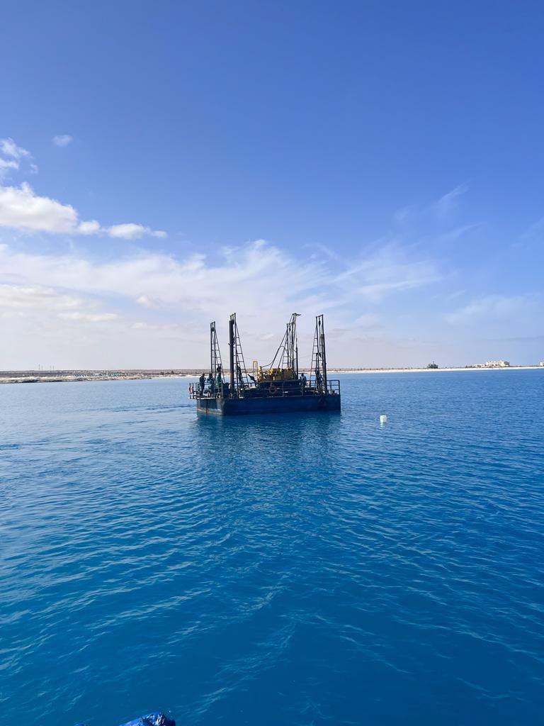
Cased marine boreholes advanced from floating pontoons, jack-ups or vessels, with heave compensation and casing support through the water column into the seabed.

Service
Marine geotechnical investigation across Egypt's Mediterranean and Red Sea coasts — drilling and sampling from floating pontoons and vessels, for ports, breakwaters, pipelines and coastal protection works.
Overview
Offshore works leave no margin for uncertainty. Piles are long, loads are high, and remediation once marine construction has started is punishingly expensive — so the investigation carries more weight in the design than its onshore equivalent ever does.
Horema works nearshore and offshore from floating pontoons, jack-up platforms and vessels, using dedicated marine sampling equipment. The challenge in Egyptian waters is rarely reaching depth; it is recovering samples of usable quality from soft, sensitive Delta deposits where disturbance destroys the very strength and compressibility data the design depends on.
The work is delivered alongside international partners where programmes call for it. On the Nile Delta coastal resilience programme, Horema operated within a Dutch–Egyptian consortium with Van Oord and Marine Sampling Holland, testing to protocols agreed across the consortium so results were directly comparable with partner datasets.
Methods & standards
ASTM D2113 · BS 5930 · ISO 19901-8
Cased marine boreholes advanced from floating pontoons, jack-ups or vessels, with heave compensation and casing support through the water column into the seabed.
ASTM D1587 · piston and thin-wall tube sampling
Piston and thin-walled tube sampling in soft marine clays and silts, with sealing and controlled transport to preserve structure and moisture content between seabed and laboratory.
ASTM D1586 · ASTM D2573
Standard penetration testing and field vane shear carried out down the marine borehole, giving strength profiles in deposits too soft for reliable sample-based assessment alone.
Grab, vibrocore and gravity sampling
Near-surface seabed characterisation for dredging assessment, pipeline and cable routes, and beach nourishment source material evaluation.
ASTM & BS suite adapted for marine soils
Classification, strength, consolidation and chemical testing on marine samples, with salinity accounted for in index and chemical interpretation.
DGPS positioning with tidal correction
Borehole positions fixed by differential GPS and reduced to chart datum with tidal correction, so seabed levels and sample depths are referenced consistently across a marine campaign.
Where it applies
What you receive
Common questions
In nearshore and shallow water, boreholes are drilled from floating pontoons or jack-up platforms anchored on station, with casing supporting the hole through the water column into the seabed. Positions are fixed by differential GPS and water depths reduced to chart datum with tidal correction so that sample depths remain consistent across the campaign.
Soft marine and Delta deposits are structurally sensitive: disturbance during sampling reduces measured strength and alters compressibility, which in turn distorts settlement and stability predictions for breakwaters, quay walls and reclamation. Piston and thin-wall tube sampling, careful sealing and controlled transport exist specifically to preserve that structure, and in-situ vane testing provides an independent strength check that sampling cannot disturb.
Along the Mediterranean coast and Nile Delta, in Alexandria and Abu Qir, at Dekhela, Gargoub and Bernice Ports, and on the Suez Canal — including deep boreholes for the New Suez Canal expansion and the 1,550 m offshore pier investigation at Abu Qir.
Yes. On the Nile Delta coastal resilience programme, Horema delivered offshore and nearshore sampling within a Dutch–Egyptian consortium alongside Van Oord and Marine Sampling Holland, following data and testing protocols agreed across the consortium so results were directly comparable with partner datasets.
Where we have done it
Related services
Send us the site location, the structures planned and your programme — our team will scope the investigation and testing required.